


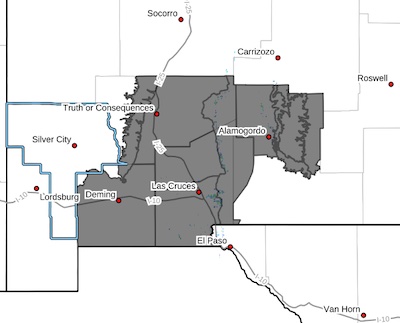
 Southwest Desert/Mimbres Basin-Eastern Black Range Foothills-
Sierra County Lakes-Northern Dona Ana County-Southern Dona Ana
County/Mesilla Valley-West Slopes Sacramento Mountains Below
7500 Feet-Sacramento Mountains Above 7500 Feet-East Slopes
Sacramento Mountains Below 7500 Feet-West Central Tularosa
Basin/White Sands-East Central Tularosa Basin/Alamogordo-
Including the cities of Sunspot, Radium Springs, Cloudcroft,
Hillsboro, Columbus, Truth Or Consequences, Timberon, Apache Summit, Derry, Alamogordo, Mountain Park, Pinon, Las Cruces,
Winston, Chaparral, White Sands Range Headquarters, Garfield,
Mescalero, Tularosa, Spaceport, Deming, Mayhill, Sunland Park,
White Sands National Park, Holloman AFB, Vado, Hatch, and
Sacramento
230 AM MDT Fri Apr 25 2025
...HIGH WIND WATCH IN EFFECT FROM SUNDAY MORNING THROUGH SUNDAY
EVENING...
* WHAT...Southwest winds 25 to 35 mph with gusts up to 60 mph
possible.
* WHERE...Sacramento Mountains, Rio Grande Valley of New Mexico,
Southwest Desert/Mimbres Basin, Eastern Black Range Foothills,
West Central Tularosa Basin/White Sands, and East Central Tularosa
Basin/Alamogordo.
* WHEN...From 11 AM Sunday morning through 8 PM Sunday evening.
* IMPACTS...Damaging winds could blow down trees and power lines.
Widespread power outages are possible. Travel could be difficult,
especially for high profile vehicles.
* ADDITIONAL DETAILS...Blowing dust is also likely in the desert
lowlands, and Advisories and Warnings will likely be issued later.
PRECAUTIONARY/PREPAREDNESS ACTIONS...
Fasten loose objects or shelter objects in a safe location prior to
the onset of winds.