


 ...CRITICAL FIRE WEATHER CONDITIONS RETURN TUESDAY... .A passing Pacific trough on Tuesday will bring a day of very strong winds, and dry conditions to Southern New Mexico and Far West Texas. Temperatures will be slightly warmer than average for the date, with afternoon instability increased. Relative humidity will drop into the high single digits and lower teens by late morning, and remain quite low well into the evening. West winds will increase through the mid morning hours and will peak during the mid and late-afternoon hours, even extending into the evening. Sustained winds at and above 35 mph with gusts exceeding 55 mph are expected. ERC values are well above average for mid March. Fire danger will be critical due to these weather conditions. Some uncertainty regarding fuels and min RH values remain for the Gila, so that zone was not upgraded to a red flag warning for this forecast cycle.
Southwest Deserts and Lowlands/Las Cruces BLM/GLZ-
South Central Lowlands and Southern Rio Grande Valley/BLM/GLZ-
Capitan and Sacramento Mountains/Lincoln NF/LNZ-
Texas Fire Weather Zone 055
El Paso County- Texas Fire Weather Zone 056
Hudspeth County-
1231 PM MDT Sun Mar 16 2025
...RED FLAG WARNING IN EFFECT FROM 11 AM TO 9 PM MDT TUESDAY FOR STRONG
WINDS, LOW RELATIVE HUMIDITY, AND HIGH FIRE DANGER...
The National Weather Service in El Paso Tx/Santa Teresa has
issued a Red Flag Warning, which is in effect from 11 AM to 9 PM
MDT Tuesday. The Fire Weather Watch is no longer in effect.
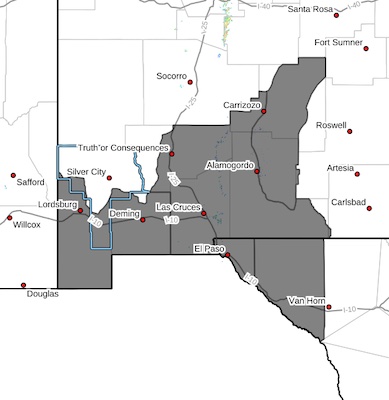
* AFFECTED AREA...All fire weather zones across Far West Texas,
Southwest and South Central New Mexico including the Lincoln
National Forest, and the lowlands and deserts across the
Borderland region. This includes fire weather zones FWZ055,
FWZ056, FWZ111, FWZ112, FWZ113.
* TIMING...11 AM through 9 PM Tuesday.
* WINDS...West 35 to 45 mph with gusts up to 75 mph.
* RELATIVE HUMIDITY...Lowlands 7-12 percent. Mountains 13-18
percent.
* TEMPERATURES...Slightly above normal. Mid to upper 70s.
* IMPACTS...any fires that develop will likely spread rapidly.
Outdoor burning is not recommended.
PRECAUTIONARY/PREPAREDNESS ACTIONS...
A Red Flag Warning means that critical fire weather conditions
are either occurring now, or will shortly. A combination of
strong winds, low relative humidity, and warm temperatures can
contribute to extreme fire behavior.