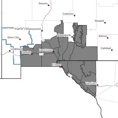
 Southwest Desert/Mimbres Basin-Northern Dona Ana County-
Southern Dona Ana County/Mesilla Valley-
West Slopes Sacramento Mountains Below 7500 Feet-
Sacramento Mountains Above 7500 Feet-
East Slopes Sacramento Mountains Below 7500 Feet-Otero Mesa-West Central Tularosa Basin/White Sands-Southeast Tularosa Basin-Western El Paso County-Eastern/Central El Paso County-Northern Hudspeth Highlands/Hueco Mountains-Salt Basin-Southern Hudspeth Highlands-Rio Grande Valley of Eastern El Paso/Western Hudspeth Counties-Rio Grande Valley of Eastern Hudspeth County-Including the cities of Deming, Columbus, Garfield, Hatch,Radium Springs, Las Cruces, Vado, Sunland Park, Mescalero,Timberon, Mountain Park, Cloudcroft, Sunspot, Apache Summit,
Mayhill, Pinon, Sacramento, Crow Flats,
White Sands National Park, Chaparral,
White Sands Range Headquarters, Orogrande, Downtown El Paso,
West El Paso, Upper Valley, East and Northeast El Paso, Socorro,
Fort Bliss, Hueco Tanks, Loma Linda, Cornudas, Dell City,
Salt Flat, Sierra Blanca, Fabens, Fort Hancock, Tornillo,
and Indian Hot Springs
133 AM MST Thu Jan 16 2025
...BREEZY TO WINDY CONDITIONS FOR FRIDAY...
Winds increase during the day on Friday as an upper-level system
swings through the region from the west. This will produce a
strong surface low in the Southern Plains and a tight pressure
gradient across our area. West winds of 25 to 35 mph are forecast
during the afternoon with gusts up to 50 mph. The strongest gusts
are expected along east slopes of the Sacramento Mountains,
Organs, and Franklins. With the combination of gusty winds, warmer
temperatures, and recent dry conditions, blowing dust will be a
concern along the International border Friday afternoon and
evening. Winds decrease Friday evening but remain breezy for
Saturday.


