

 Click to Search
Search
[{{{type}}}] {{{reason}}}
{{/data.error.root_cause}}
{{{_source.title}}} {{#_source.showPrice}} {{{_source.displayPrice}}} {{/_source.showPrice}}
{{#_source.showLink}} {{/_source.showLink}} {{#_source.showDate}}{{{_source.displayDate}}}
{{/_source.showDate}}{{{_source.description}}}
{{#_source.additionalInfo}}{{#_source.additionalFields}} {{#title}} {{{label}}}: {{{title}}} {{/title}} {{/_source.additionalFields}}
{{/_source.additionalInfo}}
Weather
- Category: Weather
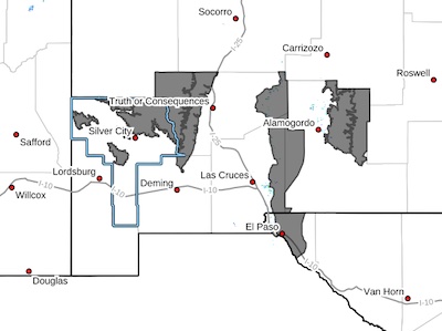 Eastern Black Range Foothills-Sacramento Mountains Above
7500 Feet-East Slopes Sacramento Mountains Below 7500 Feet-
Southern Gila Region Highlands/Black Range-West Central Tularosa
Basin/White Sands-Eastern/Central El Paso County-
Including the cities of Kingston, East and Northeast El Paso,
Fort Bliss, Winston, Pinon, White Sands Range Headquarters,
Socorro, White Sands National Park, Mayhill, Sunspot, Cloudcroft,
Apache Summit, Hillsboro, Sacramento, Lake Roberts, and Chaparral
- Category: Weather
 MARGINALLY CRITICAL FIRE WEATHER CONDITIONS FOR SOUTHERN NEW MEXICO AND WEST TEXAS ON SUNDAY... ...CRITICAL TO NEAR EXTREME FIRE CONDITIONS FOR SOUTHERN NEW MEXICO AND WEST TEXAS ON TUESDAY... .Breezy west flow continues today with a lee surface low over eastern New Mexico. Winds will be slightly weaker than Saturday, but still likely to reach critical thresholds and promote rapid fire spread. The winds, in combination with very low humidity and critically dry fuels, will lead to critical fire weather conditions for several hours Sunday afternoon. Another system will approach the area on Tuesday, which will bring strong winds with 20-foot gusts as high as 50 MPH. Lowland RH values will drop well into the teens with values of 15 to 25 percent in the mountains. Nevertheless, given the dry fuels, the fire danger will remain very high in the Lincoln and Capitan National Forests and is included within the Fire Weather Watch
- Category: Weather
DIFFICULT DRIVING CONDITIONS from Deming to Akela
I-10 eastbound and westbound lanes from milepost 94 to 102(Akela), use caution, high winds and areas of limited visibility due to blowing dust. The NMDOT will continue monitoring the roadway. This event will be updated as conditions change.
- Category: Weather
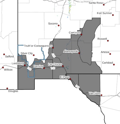
 CRITICAL FIRE WEATHER CONDITIONS FOR PORTIONS OF SOUTHERN NEW MEXICO AND WEST TEXAS ON SATURDAY... .Increasing west to southwesterly flow aloft will induce lee surface troughing across the Front Range of Colorado and Eastern Plains of New Mexico Saturday afternoon. Breezy to low-end windy conditions will result across southern New Mexico. These winds in combination with very dry air and critically dry fuels will promote critical fire weather conditions.
Southwest Deserts and Lowlands/Las Cruces BLM/GLZ-
South Central Lowlands and Southern Rio Grande Valley/BLM/GLZ-
Capitan and Sacramento Mountains/Lincoln NF/LNZ-
Texas Fire Weather Zone 055
El Paso County- Texas Fire Weather Zone 056
Hudspeth County-
455 AM MDT Thu Mar 27 2025
- Category: Weather
HIGH WIND WEATHER ADVISORY:
High wind warning in Hildago County, visibility is low in areas due to blowing dust. I-10 milepost 10-15 has areas of intermittent low to zero visibility. High profile vehicles please use caution. The NMDOT will continue monitoring the roadway. This event will be updated as conditions change.
- Category: Weather
DIFFICULT DRIVING CONDITIONS in Deming to Columbus
Difficult Driving Conditions, NM 11 eastbound and westbound from mile marker 13, 9 miles north of Columbus to mile marker 31, 2 miles south of Deming. Blowing dust may cause limited visibility.
DIFFICULT DRIVING CONDITIONS in Deming
Difficult Driving Conditions, NM 549 eastbound and westbound from mile marker 0 to mile marker 31. Blowing dust may cause limited visibility.
DIFFICULT DRIVING CONDITIONS in Deming to Las Cruces, Open
I-10 eastbound and westbound lanes are now open at exit 85, law enforcement will be escorting traffic due to heavy congestion. . The NMDOT will continue monitoring the roadway. This event will be updated as conditions change.
DIFFICULT DRIVING CONDITIONS in Deming to Silver City, open
Difficult Driving Conditions, US 180 eastbound and westbound from mile marker 164, Deming to mile marker 131, 4 miles east of Hurley due to areas of blowing dust and low visibility. The NMDOT will continue monitoring the roadway. This event will be updated as conditions.
DIFFICULT DRIVING CONDITIONS in Deming to Hatch, open
Difficult Driving Conditions, NM 26 eastbound and westbound from mile marker 0 to mile marker 44, 3 miles west of Hatch. Blowing dust may cause limited visibility. The NMDOT will continue monitoring the roadway. This event will be updated as conditions change.
I-10, and NM 9 are all still closed.
- Category: Weather
 The National Weather Service in El Paso has issued a
* Dust Storm Warning for...
South central Grant County in southwestern New Mexico...
Luna County in southwestern New Mexico...
Central Hidalgo County in southwestern New Mexico...
* Until 715 PM MDT.
* At 418 PM MDT, an area of blowing dust was covering much of
Southwest New Mexico.
HAZARD...Near zero visibility with damaging winds in excess of 60
mph.
SOURCE...Satellite imagery.
- Category: Weather
DIFFICULT DRIVING CONDITIONS in Deming to Hatch
Difficult Driving Conditions, NM 26 eastbound and westbound from mile marker 0 to mile marker 44, 3 miles west of Hatch. Blowing dust may cause limited visibility. The NMDOT will continue monitoring the roadway. This event will be updated as conditions change.
DIFFICULT DRIVING CONDITIONS in Deming to Silver City
Difficult Driving Conditions, US 180 eastbound and westbound from mile marker 164, Deming to mile marker 131, 4 miles east of Hurley due to areas of blowing dust and low visibility. The NMDOT will continue monitoring the roadway. This event will be updated as conditions.


Content on the Beat
WARNING: All articles and photos with a byline or photo credit are copyrighted to the author or photographer. You may not use any information found within the articles without asking permission AND giving attribution to the source. Photos can be requested and may incur a nominal fee for use personally or commercially.
Disclaimer: If you find errors in articles not written by the Beat team but sent to us from other content providers, please contact the writer, not the Beat. For example, obituaries are always provided by the funeral home or a family member. We can fix errors, but please give details on where the error is so we can find it. News releases from government and non-profit entities are posted generally without change, except for legal notices, which incur a small charge.
NOTE: If an article does not have a byline, it was written by someone not affiliated with the Beat and then sent to the Beat for posting.
Images: We have received complaints about large images blocking parts of other articles. If you encounter this problem, click on the title of the article you want to read and it will take you to that article's page, which shows only that article without any intruders.
New Columnists: The Beat continues to bring you new columnists. And check out the old faithfuls who continue to provide content.
Newsletter: If you opt in to the Join GCB Three Times Weekly Updates option above this to the right, you will be subscribed to email notifications with links to recently posted articles.
Editor's Notes
It has come to this editor's attention that people are sending information to the Grant County Beat Facebook page. Please be aware that the editor does not regularly monitor the page. If you have items you want to send to the editor, please send them to editor@grantcountybeat.com. Thanks!
Here for YOU: Consider the Beat your DAILY newspaper for up-to-date information about Grant County. It's at your fingertips! One Click to Local News. Thanks for your support for and your readership of Grant County's online news source—www.grantcountybeat.com
Feel free to notify editor@grantcountybeat.com if you notice any technical problems on the site. Your convenience is my desire for the Beat. The Beat totally appreciates its readers and subscribers!
Compliance: Because you are an esteemed member of The Grant County Beat readership, be assured that we at the Beat continue to do everything we can to be in full compliance with GDPR and pertinent US law, so that the information you have chosen to give to us cannot be compromised.
Submitting to the Beat
Those new to providing news releases to the Beat are asked to please check out submission guidelines at https://www.grantcountybeat.com/about/submissions. They are for your information to make life easier on the readers, as well as for the editor.
Advertising: Don't forget to tell advertisers that you saw their ads on the Beat.
Classifieds: We have changed Classifieds to a simpler option. Check periodically to see if any new ones have popped up. Send your information to editor@grantcountybeat.com and we will post it as soon as we can. Instructions and prices are on the page.